Wandering through Guadalupe Canyon to the Southwest Corner of New Mexico
By: David Ryan
"In the course of working on Wandering in the Clear Light of New Mexico and after other travels, I managed to get to the Northwest, Northeast, and Southeast corners of New Mexico. But I never ventured to the Southwest corner of the State, where New Mexico, Arizona, and Mexico converge. This gave me the idea that I should check it out. (If you’ve read The Gentle Art of Wandering, you may remember the importance of having an Idea to initiate a wandering adventure.)
While gathering information, I learned that the Southwest Corner is located in a very rugged and remote tract of BLM (Bureau of Land Management) land. I also learned that the best (and only) access would be from Douglas, Arizona and that the adventure would involve walking through Guadalupe Canyon on private land. Fortunately, after reading various write-ups that I found on the Internet from other people who had explored the area, I learned that access is okay if you’re on foot and don’t hunt or trap. (You may also remember from The Gentle Art of Wandering the value of fleshing out your Idea by developing some Context for your adventure is important, but ultimately the Idea and Context only have meaning when you take Action and actually get out there and do it.)
In further readings, I learned that Guadalupe Canyon has plenty of history related to the Apache and Old West Lawmen and Bad Guys, but more importantly it is located where multiple eco-zones and wildlife from both sides of the border come together to make this a sought after location by birdwatchers. It is also where jaguars are believed to cross from Mexico into the United States.
And this brings us to another component of Guadalupe Canyon and the Southwest Corner of New Mexico – the Border Wall. With the rugged mountainous terrain, the Wall is not complete. Building the Wall near Guadalupe Canyon required blasting away a huge portion of the mountains, and with all of that construction the Wall is still not done and has not reached the New Mexico border. According to what I have read, at a cost of $41 million dollars per mile, this is one of the most costly sections of the wall.
With so much to check out, I was chomping at the bit to go! In full disclosure, it took me three attempts to see the Corner Monument. But I like to think of those first two attempts as reconnaissance trips to test out possible routes. Even better, the additional walks gave me more reasons to visit this incredible corner of the world. Each walk was fantastic and I can’t wait to get back!
If you want to check this area out, you’ll start in Douglas and go east on 15th Street. When 15th Street crosses Airport Road it becomes the Geronimo Trail. At this point you’ll be leaving the townscape and entering the desertscape. The pavement ends in a little over four miles, but the road continues to be very good.
The Geronimo Trail follows the topography in and out from the border. So you’ll have plenty of chances to see the Border Wall and may even ping a Mexican cell tower and get a Welcome to Mexico message on your phone. But in all likelihood, you’ll be out of cell phone range for most of the drive.
In just short of 14 miles, you’ll pass a Mormon Battalion monument and pass the entrance to the Slaughter Ranch (now a National Wildlife Refuge). The Morman Battalion marched from Iowa to San Diego during the Mexico War of 1846-48. There are several monuments marking their route. Additionally, if you’re old enough, you might remember the 1958 TV Western – Texas John Slaughter – and its catchy theme song.
Texas John Slaughter made ’em do what they oughter
Cuz – if they didn’t – they died!
At 20 miles or so you’ll reach a major junction. The Geronimo Trail heads to the northeast while Guadalupe Canyon Road heads southeast. (The Geronimo Trail was the route of the Mormon Battalion.) Take Guadalupe Canyon Road. In 9 more miles, you’ll reach another junction. The wider road to the right leads to a construction staging area for the Border Wall. Take the smaller road to the left. It reaches the Guadalupe Ranch gate in a little over a half-mile. It’s now time to park the car and start walking."
Click here to read the full article.
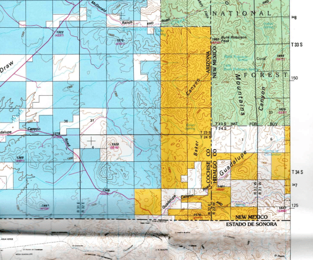
 "This is from a BLM Land Status map. White is private land; Yellow/Orange is BLM land; Green is Forest Service land; and Blue is State Land." |  "Here’s a drone shot of the Wall at Guadalupe Canyon. The gate for Guadalupe Ranch is down below." |
 "Sycamores in the Fall." |  "Here’s the Arizona/New Mexico boundary looking west from New Mexico into Arizona." |
